
Google lumikha ng consolidated map ng mga evacuation center para sa mga nasalanta ng pagputok ng Bulkang Taal
By Dona Dominguez-Cargullo January 17, 2020 - 04:17 PM
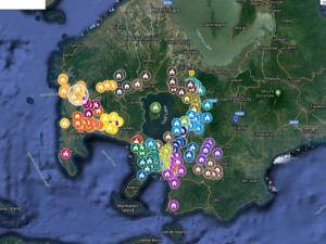 Isang consolidated map ang nilikha ng Google Philippines na nagpapakita ng lugar na kinaroroonan ng mga evacuation center para sa mga biktima ng pagputok ng Bulkang Taal.
Ayon sa Google ang source ng mga lugar ng evacuation center ay ang Batangas Public Information Office.
Para mahanap ang map, magtungo lamang sa google.com
At pagkatapos ay i-click ang “Evacuation centers for the Taal eruption”
Ayon sa Google, magagamit ito hindi lamang ng mga evacuee kundi maging ng mga nagbibigay ng tulong.
Disclaimer: The comments uploaded on this site do not necessarily represent or reflect the views of management and owner of Cebudailynews. We reserve the right to exclude comments that we deem to be inconsistent with our editorial standards.