
Signal No. 3 nakataas sa 9 na lugar sa bansa dahil sa Typhoon Ursula
 Marami pang lugar ang nakasailalim sa tropical cyclone wind signal dahil sa Typhoon Ursula.
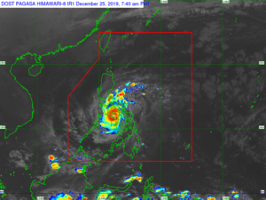
Sa 8AM weather bulletin ng PAGASA ang bagyo ay huling namataan sa layong 30 kilometers Northwest ng Roxas City, Capiz o sa layong 95 kilometers South Southeast ng Romblon, Romblon.
Taglay ng bagyo ang lakas ng hanging aabot sa 140 kilometers bawat oras at pagbugsong aabot sa 195 kilometers bawat oras.
Kumikilos ang bagyo sa bilis na 20 kilometers bawat oras sa direksyong pa-kanluran.
Nakataas ang Tropical Cyclone Wind Signal Number 3 sa sumusunod na lugar:
– Western Masbate (Milagros, Aroroy, Mandaon, Balud)
– Romblon
– southern Oriental Mindoro (Roxas, Mansalay, Bulalacao, Bongabong, Bansud)
– southern Occidental Mindoro (Calintaan, Rizal, San Jose, Magsaysay, southern portion of Sablayan)
– Calamian Islands (Busuanga, Coron, Culion)
– Capiz
– Aklan
– northern Antique (Caluya, Libertad, Pandan, Sebaste, Culasi, Tibiao, Barbaza, Laua-an)
– northern Iloilo (Calinog, Bingawan, Passi City, San Enrique, San Rafael, Barotac Viejo, Ajuy, Lemery, Sara, Concepcion, San Dionisio, Batad, Estancia, Balasan, Carles)
Tropical Cyclone Wind Signal Number 2:
– Southern portion of Quezon (Macalelon, General Luna, Catanauan, Mulanay, San Narciso, San Andres, San Francisco)
– Marinduque
– rest of Oriental Mindoro
– rest of Occidental Mindoro including Lubang Island
– Albay
– Sorsogon
– Rest of Masbate including Ticao and Burias Islands
– Cuyo Islands
– extreme northern portion of mainland Palawan (Linapacan, El Nido, Taytay, Araceli)
– Extreme northern Cebu including Bantayan Islands (Daanbantayan, Medellin, Bantayan, Sta. Fe, Madridejos, Bogo City, San Remigio, Tabogon, Tabuelan), the rest of Iloilo, the rest of Antique, Guimaras, and northern Negros Occidental (Valladolid, Pulupandan, Bago City, Murcia, San Carlos City, Salvador Benedicto, Bacolod City, Talisay, Silay City, Enrique B. Magalona, Victorias City, Manapla, Cadiz City, Sagay City, Escalante City, Toboso, Calatrava)
Tropical Cyclone Wind Signal Number 1:
– Bataan
– Metro Manila
– Rizal
– Cavite
– rest of Quezon
– Laguna
– Batangas
– Camarines Sur
– Camarines Norte
– Catanduanes
– rest northern mainland Palawan (Dumaran, San Vicente, Roxas)
– Cagayancillo Islands
– Northern Samar
– Samar
– Eastern Samar
– Biliran
– Leyte
– Bohol
– rest of Cebu
– rest of Negros Occidental
– Negros Oriental
Ayon sa PAGASA, ang eyewall ng Typhoon Ursula ay naghahatid ng napakalakas na hangin at intense rainfall sa southwestern Masbate, Aklan, Capiz, northern Antique, northeastern Iloilo, at Romblon.
Sa susunod na mga oras, maaapektuhan na rin ng eyewall ng bagyo ang southern portion ng Mindoro Provinces.
Narito naman ang Heavy Rainfall Outlook ng PAGASA sa ulang idudulot ng bagyong Ursula…
• Until tonight
– Occasional to frequent heavy with intermittent intense rains over Masbate, northern Negros Provinces, Aklan, Antique, Capiz, Iloilo, Guimaras, Romblon, Calamian Islands, Cuyo Islands, and Mindoro Provinces. Light to moderate rains with isolated heavy rainshowers during thunderstorms over Bicol Region, rest of Visayas, CALABARZON, Metro Manila, Marinduque, Aurora and the northern portion of mainland Palawan
– Moderate to strong winds to begin affecting the northern portion of Palawan and most of CALABARZON this morning; Metro Manila and Bataan between this morning and afternoon.
Pinag-iingat ang lahat ng residente sa mga lugar na apektado ng bagyo.
Disclaimer: The comments uploaded on this site do not necessarily represent or reflect the views of management and owner of Cebudailynews. We reserve the right to exclude comments that we deem to be inconsistent with our editorial standards.